Grand Western Canal
The canal, which was opened in two stages, Tiverton to Lowdwells in 1814, and Taunton to Lowdwells in 1838, ran from Taunton, Somerset, to Tiverton in North Devon.
The Taunton to Lowdwells section, a distance of around 13miles, is generally fragmented with many parts missing or difficult to see any more. It originally had 1 incline and 7 lifts to raise the level up by 262ft over its route to Lowdwells, where there was a lock finally raising the water level by 3 ½ ft. There was also a stop lock at Taunton.
In contrast, the Lowdwells to Tiverton section, a distance of about 11.34 miles, is level with no locks or inclines, is almost completely passable by boat after much renovation in the 1970’s and 80’s, and has good paths for walking or cycling along its entire length.
Last updated on 19th April 2010.
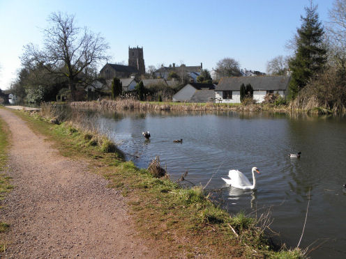
The canal at Sampford Peverell looking west towards the Church & Rectory
Background information about the canal.
1810 : The
1814 : This section was completed.
1831 : The digging of the second stage of the canal from
1838 : This section was completed and the canal was at last fully opened on 28th June.
On the
Taunton 23 ½ ft, Norton 12 ½ ft, Allerford 19ft, Trefusis 39 ½ ft, Nynehead 24ft, Winsbeer 18ft, Greenham 42ft,
The one inclined plane was at Wellisford, a rise of 81ft over a length of 440ft, a gradient of 1 in 5 ½ .
Somerset:
Where to see the remains of the canal
Frieze Hill on the A3027 heading out of Taunton towards Norton.
Bishops Hull. North of the village on the minor road that passes over the river Tone. Take the footpath on the left before the brook crosses the road.
Longaller to the west of Bishops Hull at Barr. Reached via the footpath above?
Allerford . The road heading SE goes over the railway and the canal remains are near the pub nearby (was the Victory Inn).
Trefusis Cottage on the Tone Green, Hillfarrance road.
Trefusis Farm on the Tone Green,
Clavenger Farm just south of East Nynehead.
Wharf Cottage on the Wellington, Nynehead road. See pictures below.
Tonedale on the
Wellisford, the site of the inclined plane. On old maps cottages are identified as Incline cottages.
Cothay Barton or Manor near Kittisford. The canal passed east of it near Cothay Bridge cottages,
Wharf Cottage, Nynehead
http://cid-f2f65a21417102d0.skydrive.live.com/self.aspx/Canals/gwcnyneheadAlbum101.jpg
5890 view of the canal from the road, 5891 Wharf cottage on the Nynehead road, 5892 the end of the canal and the 24ft lift walls in the distance, 5893/4 the remains of the lift walls, 5895 the upper level above the lift walls, 5896 looking back towards Wharf cottage from the upper level, 5897 one side of the iron aqueduct with the railway bridge in the distance, 5898 the iron aqueduct over the driveway to Nynehead Court, 5899/90/1 view of the aqueduct from the field where the driveway passed through, 5902 the railway bridge through the archway of the aqueduct, 5903 the aqueduct from the railway bridge, 5904 a train passing over the railway bridge, 5905 a gate marks the route the driveway would have taken to Nynehead Court, 5906 a reed cutting machine near Wharf Cottage, 5907 entrance to the driveway at Nynehead Court Lodge.
Devon:
Where to see the remains of the canal
There are many places along the 11.34 mile length that runs from Lowdwells to Tiverton.
At Lowdwells there is a car park and picnic site. Similar facilities can be found at Westleigh, Ebear bridge, Sampford Peverell (includes the Bodmin, a converted working barge), Greenway bridge and Tiverton road(off A373).
The following towns and villages and Hamlets are on or nearby the canal:
Lowdwells: Lowdwells Lock
Waytown Tunnel (40yd) & Lime kilns
Whipcott: Whipcott wharf, Whipcott bridge
Fenacre Bridge
Burlescombe/ Westleigh: Fossend Bridge, Black bridge and abandoned tramway
Ebear Bridge
Westcott bridge
Ayshford bridge
Holbrooke bridge
Sampford Peverell Bridge
Battens bridge
Watton bridge
Rock Bridge
Greenway Bridge in Halberton
Tiverton Road (formerly A373)
Crowshill Bridge
aqueduct over Tiverton Railway
Manley Bridge
Tidcombe Bridge
Tiverton Basin
Tiverton
A Series of Photo Albums starting at Lowdwells,
and finishing at Tiverton Basin.
Lowdwells to Ebear bridge just ne of Sampford Peverell. Pictures taken 11th Feb 2010
http://cid-f2f65a21417102d0.skydrive.live.com/self.aspx/Canals/gwc110210Album101.jpg
002/3 Lowdwells approaching Lock cottage on the right, 004 the site of the lock at Lowdwells at left, which linked the other stretch of the canal to Taunton, 005 looking NE to the remains of the canal on the Taunton side of the Lowdwells lock, 006 looking SW along the start of the navigable canal, quite shallow at this point, 007 heading on towards wharf house just north of Waytown tunnel, 008 looking back to Lowdwells lock, 009 looking through the trees to the north side of Waytown tunnel with the road to the wharf on the left hand side, 010 wharf house, 011 wharf house, approach road and the tunnel entrance, 012/3 where the canal crossed the road back at Lowdwells, 014 looking SW from above Waytown tunnel, 015 Waytown Limekilns in the distance on the right, 016 south side of Waytown tunnel, 017/8/9 Waytown Limekilns, 020 looking south from the limekilns, 021 information board at the kilns, 022/3 Whipcott wharf from the bridge, 024 looking south towards Fenacre bridge, 026-31 north side of the bridge, 032/3 looking south towards Fenacre bridge, 034 Whipcott bridge and cottage, 0035 n towards Westcott bridge from a little north of Fenacre bridge, 036 south towards Fenacre bridge from below the parking area, 037 north towards Fenacre bridge from Fossend bridge in Westleigh, 038 the wharf at Fossend bridge, 039 looking south towards the black bridge that supported the tramway from Burlescombe station to the quarries at Westleigh, 040 looking north under Fossend bridge, 041 south side of Fossend bridge, 0042 north side of the black bridge tramway, 043 looking north past black bridge to the wharf on the left and then Fossend bridge, 044 the wharf on the left and then Fossend bridge, 045/6 ruins of a 13th c nunnery to the north of the Westleigh road, 047 Canonsleigh farm and mill buildings, 048 limekilns at the end of the tramway near the quarries at Westleigh, 049 Ebear bridge, 050 looking sw towards Westcott bridge from Ebear bridge, 052 looking ne towards Burlsecombe from Ebear bridge, 053/4 north side of Ebear bridge, 055 south side of Ebear bridge, 056 looking sw towards Westcott bridge, 057/8 looking ne from Sampford Peverell bridge, 059 looking south, 060 looking north under the bridge, 061 information board at Sampford Peverell, south side of Sampford Peverell bridge,
Ayshford Bridge to Greenway Bridge Pictures taken 5th March 2010
http://cid-f2f65a21417102d0.skydrive.live.com/self.aspx/Canals/gwc050310Album101.jpg
P3050002 Ayshford bridge from the east, 003 Ayshford Chapel looking east from near the bridge, 004 looking west from the bridge, 005 the bridge from the west, 006 Holbrooke Bridge from the east, 007 and from the west, 008 and looking north over the bridge, 009 info board at Sampford Peverell near the car park, 010 looking east towards Buckland Bridge, 011 west towards Sampford Peverell church, 012 a little nearer, 013 the church comes into view, 014 looking west towards Sampford Peverell bridge, 015 looking south over Battens Bridge, 016 looking east towards Sampford Peverell from Battens Bridge, 017 south side of the bridge, 018 looking south towards Watton Bridge, 019 Rock House to the north side of Rock Bridge, 020 the Wharf and cottage to the west side of Rock Bridge, 021 looking north over Rock Bridge with Rock House on the right, 022 looking east to Watton Bridge, 023 Rock House from the south, 024 Rock cottage, 025 east side of the bridge, 026 another view of the wharf, 027 just east of Swing Bridge looking back towards Rock Bridge, the cottage on the right is reputed to have been built for a man whose duty once a day, was to check the embankment for leaks, 028/9 Swing Bridge, although it does not swing anymore, 030 looking west towards Greenway Bridge at Halberton, 031 Swing Bridge from the west, 032 Swing Bridge, 033 looking east towards Swing Bridge from Greenway Bridge, 034 view to the west from Greenway Bridge where the ‘Swans neck’ section loops away to the right and then swings back around to the left, 035 west side of Greenway Bridge, 036 east side, 037 looking west under Greenway Bridge,
Greenway Bridge, Halberton, to Tiverton Basin: 16th April 2010-04-19
http://cid-f2f65a21417102d0.skydrive.live.com/self.aspx/Canals/gwc160410Album101.jpg
P4160001 view across to Greenway bridge from Tiverton road bridge, 002 the canal embankment a little to the west of Halberton, 003 Dudley Weatherley Jubilee bridge, a metal lift up bridge, 004 the north side of Tiverton road bridge, 005 the south side, 006 looking south from Tiverton road bridge, 007 Crownhill bridge from the north, 009 postvan crosses the bridge, 010 looking north from Crownhill bridge, 011 looking south, 013/4 south side of the bridge, 015 looking north over the Aqueduct, 016 looking south to the moorings of the Mid Devon Hire Boat Co, 017 on the trackbed of the old Tiverton Junction to Tiverton branch line, looking west towards the Aqueduct, 018 as before, a little nearer looking under the roadbridge to the double tunnels of the Aqueduct structure, 019 the Aqueduct from the east, 020 the cast iron structure, 021 another view of the brickwork from the east, 022 looking east from Manley bridge, 023 Manley bridge from the east,
Tiverton Basin to Warnicombe bridge
http://cid-f2f65a21417102d0.skydrive.live.com/self.aspx/Canals/gwctivertonAlbum101.jpg
277 the end of the canal above the stone walls, , 278 Lime Kiln cottage, 1280 Tidcombe Bridge, 1284/5 Warnicombe bridge, 1288/9 looking west to the end of the canal, 464/5/6 the horse drawn canal boats of the Grand Western Canal Horseboat Co,