Durston – Yeovil Branch Line
Railway
Last updated 31st Aug 2013
This Branch Line opened in 1853 and closed in 1964.
The pictures can be seen at the following location:
http://cid-f2f65a21417102d0.skydrive.live.com/self.aspx/Somerset%20villages/dyrailwayAlbum101.jpg
As well as the pictures featured below, which shows some of what can
still be seen now, there is a Langport Postcard album
which shows a number of old views of this branch line. https://skydrive.live.com/?cid=f2f65a21417102d0&id=F2F65A21417102D0%21362
The Durston to Langport section.
Durston Junction was located east of Durston in the hamlet of Outwood, on the east side of the road bridge over the main line railway.
Here there was the junction, a station, no longer existing, and also a Railway Hotel, which is still there although now a private dwelling with a ‘Keep Out’ sign.
545/6 looking south to the road bridge over the railway, 547/8 the line
looking north east with the now derelict site of the junction and station on
the right hand side, 549 the line looking sw towards
From here the railway branched off north east from the Bristol/ Exeter GWR main line and swung round in a big curve to head east to Lyng, where it crossed the main road just west of East Lyng.
About half a Km west of Athelney Station, the old line runs parallel with the 1906 GWR main line thatlinked Castle Carey to Taunton, and heads south east to cross the river Tone near Athelney Station. This new main line, opened in 1906, shortcut the loop to Durston, and connected to the Bristol Exeter mainline at Cogload junction, south east of Durston. The section from Athelney to the river Parrett at Langport adopted that part of the old branch line.
Carrying on roughly south east the line reached Oathe, and then it turned due east, and just before reaching the river Parrett it swung south into Langport West Station.
Pictures on the Durston to Langport section:
61546/553 the road bridge over the line at Outwood, 547/8 looking down on the line where Durston junction & station were located, 550/1 The old Station Hotel, 71601/3 the main line to the west of the Athleney road crossing. The branch line came in from Durston from the left, 622 west of Langport at Portfield Lane the line swung in from the mainline and crossed this dead end road. This view looks towards Langport west Station, 623 same as before but zoomed in, 624 looking the other way towards the mainline, PB030009 view of the main line with the branch line, represented by the hedgerow, swinging in towards Langport. On the left you can just make out the sewage works.
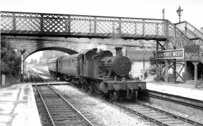
A train heads south under the road bridge and foot bridge into Langport West station.
The Langport to Martock section
Leaving Langport West station it headed south across the moors, running parallel with the river Parrett, passing the Muchulney road over Westover Farm bridge and then quickly crosses the river over Parrett bridge, before heading south east to pass under Thorney Bridge. Eventually it passes under Coat Bridge and heads on into Martock station.
Pictures on the Langport to Martock section:
0472/3/5 Looking south along the Parrett cycleway which uses the old trackbed from near Langport West
station, south to the Drayton road. 3540 The remains of Parrett bridge 3541
view from Langport roadbridge
looking down to where the station used to be. 3542 looking the opposite way
north towards where the line left the main line. 3544 looking along the road bridge towards
The Martock to Yeovil
section
Pictures on the Martock to
Yeovil section
PB230002/3 Stepps meadow, east of the station at Martock, PB230004 Looking E from Foldhill Lane, PB230006 Looking SE across Cartgate roundabout on the A303, PB230007/8 looking west back towards Martock, PB230009 looking SE towards the roundabout, PB230010 looking west from Watercombe Lane bridge, PB230011/12 looking east from the bridge towards Yeovil, PB230013 west side of the bridge, PB230014 Brympton bridge looking North, PB230015 looking west from Brympton bridge, PB230016 looking east, PB230019/20 looking north from the Montacute road bridge, PB230021 looking east from Montacute road bridge, PB230022 looking west.